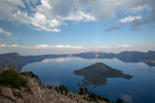
Crater Lake from The Watchman
[photos: flickr – Lava Beds Revisited]
[photos: flickr – Crater Lake NP]
I was looking at a map of Oregon thinking I should go explore the central and eastern part of the state. I spotted Crater Lake and it reminded me I wanted to go there. Google Maps had suggested an alternate route there through Reno and up highway 395, about two hours longer than the trip up I-5. At first this seemed ridiculously funny but then I warmed to the new route because I’d see new scenery in northeastern California. I’ve already seen fireworks show in the Bay Area (and they’re a bit of a hassle to go to), so I opted to go up there instead of hang around at home for Independence Day.
On Tuesday the 3rd I headed out. The holiday traffic was already filling up the freeways, so I opted not to go the Reno route. The thought was to get up near the park or Klamath Falls and camp in the forest. I got near the Modoc forest around 9 PM and it was already getting dark. I decided to camp at the Lava Beds park and scored a site at the campground there (I wanted a fire). I didn’t even bother pitching my tent, I just laid my sleeping bag on the picnic table. The sky was clear and dark, so I spent a while taking Milky Way photos. The last time I was here was in the summer of 2016.
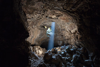
Beam of sunlight in Sentinel Cave
Wednesday morning I went into a couple of the lava tubes because I wanted to see what my TNV/PVS-14 did in the pitch dark caves. With just a little red LED light it gave the PVS-14 something to work with and I was able to navigate. Other than constant re-focusing I think it would be just fine with a brighter IR flashlight. After leaving the park and on the way to Klamath Falls I stopped over and visited the petroglyph site too.
I rolled into the Crater Lake park around 3 PM. At first I went to the ranger station to ask about dispersed camping outside the park (which would’ve been several miles), but wound up at the campground at Mazama Village. Amazingly they had sites still available despite being a major holiday. The guy right in front of me registered the last tent site, but the employee talked me into getting one of the remaining RV sites and just putting my tent there, so that’s what I did.
View from The Watchman
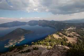
With camp now squared away I went up to the crater. First impression was that it was a really big lake hidden among all the trees and the water was a really rich, deep dark blue. After a couple of stops along the west side rim road I spotted The Watchman fire lookout on top of a big hill and had to go check it out. It was a little hazy due to the wildfires down south, but still offered a great view of the lake and the island.
I continued to the north and around the lake, taking photographs as the sun was going down. Cell service was nonexistent down at the campground and on the west side of the crater, but there were a few turnouts on the east side where I got AT&T LTE service. I drove out to the Pinnacles right as it started getting dark, but wasn’t too wowed by it. Mosquitos were terrible the whole way around, despite wearing 100% deet and picaridin repellent, the fuckers swarmed me when I was outside and still bit me through my shirt and socks. I guess I need to try permethrin next.
On Thursday a lot more people started rolling into the park. This time I started off on the eastern side of the rim and went around. I learned that there was a boat tour you could take if you were lucky enough to get tickets. I didn’t have one, but wanted to get closer to the water so I went down to the boat dock. It’s a long, hot hike down from the rim to the water, a bit over a mile, and a 600 foot elevation difference.
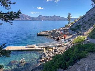
Cleetwood Cove boat dock
Down at the water’s edge, people were fishing, and jumping off boulders into the water. It was pretty cold water, but crystal clear and pretty. I’d like to take the boat tour someday, going over and hiking up Wizards Island looks interesting. Hiking back up to the rim wasn’t toooo bad, it went quicker than I expected. I saw people making the walk in flip flops and pushing strollers, sucks for them!
By the time evening rolled around I debated just going back to camp or hanging out until nightfall and taking Milky Way photos over the lake. I still had a few hours so I grabbed a bite to eat at Rim Village and went north out of the park to see what was there. Near Diamond Lake I spotted a black bear on the highway right-of-way, the first time I’ve ever seen a bear! It ran back into the tree line as I got closer, I wasn’t able to get a picture of it.
At dusk I set up on the north side of the rim for a time lapse shot over the island. I fiddled with settings for a bit, doing a 30 second exposure every minute, then finally settled on an exposure every 30 seconds to have a smoother time lapse. It didn’t turn out as good as I had hoped, there was still a bit of haze and there were clouds rolling in. It was really windy and cold, by midnight I had had enough. I had failed to check the weather in the morning, now there was a slight chance of rain, so I packed it in and headed back down to camp where I had left my rain fly half on and all of my sleeping stuff exposed.
Friday morning I packed up camp, had breakfast at the cafe, and headed out. At 11 AM there was a good mile-long string of cars trying to enter the park. I stopped by the Annie Creek Sno-Park, a few miles from the park, one of the places the ranger suggested for camping. It was a big asphalt parking lot, with vault toilets on one end, fire rings on the other end, and a log building that served as a snow shelter. Not exactly scenic camping, but it would do if the park was full; best of all it was free during the summer!
The drive back home was uneventful. On the way back I followed highway 395 down, which took me back through the Lava Beds, along the eastern edge of California, and into Reno. No windshields were damaged on this trip.