flickr: Dead Horse, Canyonlands
flickr: scenic drive, GS-E, Dixie
After taking my truck to the mechanic, he decided there wasn’t much to work with and misfire indicators not a big problem for now. Said it could just be a touchy airflow sensor. I took off again for Utah on Thursday, heading south along I-5, then up I-15. I left a lot later than I intended to, around 11 AM. Stopped in Barstow around 5 PM for food, it was hot, windy, and dusty af.
As a last minute idea I stopped in the Mojave National Preserve, hoping to find the spot of where the infamous Mojave Phone Booth was. Following Google I wound up I think down Cima road, which lead me to some gravel road, which lead me to a “4×4 recommended” road. The sun was just setting and I didn’t feel like looking at maps to find a better way, so I gave up and headed back to the interstate.
I love approaching the border of Nevada, no matter what interstate or highway I take through the middle of nowhere I can always find the state line because there will be some sort of casino, liquor store, and/or hotel right on the Nevada side. By 10:00 PM I hit the Arizona state line. I had sort of forgotten I-15 crossed Arizona so it was briefly worth a double look. Just 25 minutes later I was at the Utah state line. By now it was well dark and I couldn’t see any of Utah on my way through it.
Around 12:20am I finally reach I-70 to head east across Utah. Just as I turned onto I-70 I started seeing snow flurries in the headlights. Passing over the Fishlake NP the flurries were mild but it was still 24 F. When I passed through Capitol Reef NP, the snow got much worse. The road was completely white for at least an hour, I couldn’t see the lines, and barely the tire tracks in front of me. After getting down to a lower elevation the snow cleared out and everything was dry again.
Finally at 4 AM I rolled into Moab. Trip distance so far was 1,037 miles, 16 hours, essentially nonstop. It was really cold when I reached Moab, I didn’t feel like trying to find a campsite so I just checked into Motel 6 to sleep for a few hours. Pro tip: do not stay in room 111. You’ll be right next to the elevator and it noisily goes up and down nonstop by 9 AM.
April 28, morning, Moab
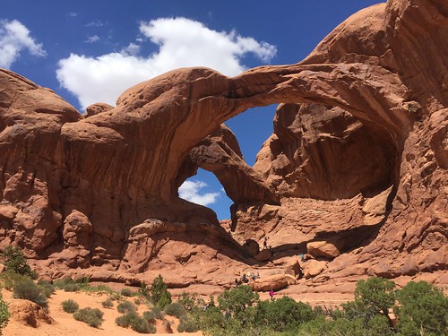
I finally got to see Moab in the morning for the first time, and I was surprised by the number of 4×4, ATV, OHV, and Jeeps running around. The Internets suggested Ekelcticafe for breakfast, which was this quaint little place and had amazing toast. They also had cricket protein bars. GROUND CRICKETS. wat? I headed up to Arches NP and there was barely any line as it was free entry this week. Hooray!
I soon discovered my new Canon 24-70/L lens completely stopped working. No matter what I did the body still threw error 99. Crap. At least I had a couple of other lenses with me to use. Walking around the arches was cool, then saw Delicate Arch was the stereotypical arch photo so I had to go hike up to it. Interestingly there’s a perfect rock ledge at the top that takes you right around. It’s pretty huge up there, with the summit and the big arch resting on sides of a crescent. Tons of people up there when I was, some doing back handstands under the arch, others doing group photos.
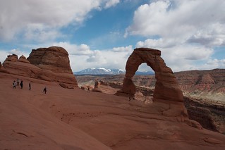
Delicate Arch
Beyond this I was getting tired and didn’t want to go walk around more, back into Moab by evening. I found our this weekend was an annual car show, so the highway downtown was full of all sorts of old cars, and the sidewalk was full of people in blankets on foldy chairs. There was more nightlife than I expected and that was pretty awesome. In a way Moab reminds me of Jackson, WY.
April 29, Canyonlands
Mesa Arch, Canyonlands
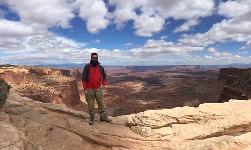
Saturday morning I headed off to Dead Horse SP and Canyonlands NP. Dead Horse had a few really awesome places where you could overlook the canyons and the Colorado River. The top of Canyonlands at Island in the Sky reminded me of Big Bend, wide open grasslands punctuated by big rocks. If you liked the Grand Canyon, you’ll probably love Canyonlands. It’s just bigger canyons to drive around.
At some point after looking at the map I discovered Shafer Canyon Road leading down to White Rim road at the canyon floor. I knew White Rim was a 4×4 road, so I figured I’d just drive down to it and come back. What I didn’t know was that Shafer was built right on the canyon wall, one lane, with very steep dropoffs, all the way down. It was very much unexpected and I was committed. Funny enough I’d also have to come back up the same way I came because I didn’t want to drive back to Moab on the back roads. It is by far the sketchiest road I’ve ever been down.
TIL Moab was also popular for Uranium mining, and there’s a Department of Energy “UMTRA” cleanup operation still going.
I was hoping to get some sunset photos, but I didn’t make it to places I wanted to in time. Back to Moab for dinner and sleep. This time I was actually staying in a motel in downtown Moab. The car show was going on again, so tons of people around again. Staying in town was worthwhile, it meant I could walk to everything. This time it started freezing drizzle+snowing later at night which sent people packing and cleared out the place.
I kinda wished I had spent the night in Canyonland instead of a motel, I think it was warmer there and would’ve been more tolerable. Star photography was out, it was still partially cloudy at night.
April 30, Hwy 12
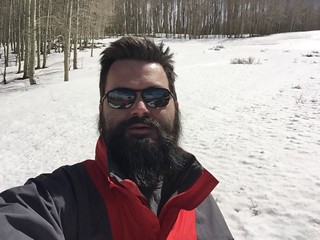
Sunday morning I departed Moab. There was quite the line to get out of town, traffic was solid from one end of town to the other. I took me an hour to finally get out. This was a completely unplanned day, I wanted to go swing through Grand Staircase-Escalante NM to check it out but I’d get there way too late to do much. At Alex’s suggestion I headed down hwy 24 to hwy 12 to take the scenic route.
I was happy when I passed through Dixie National Forest, at the top I found hillsides still full of snow several inches deep. I fulfilled my excitement of not seeing snow in years by running around in the snow and building a snowman to leave behind.
Through Capitol Reef NP I saw a spot right on the road to see petroglyphs so I stopped. I didn’t know what I was looking for at first and then finally found the little carvings in the rock face. There were several sets here and they were awesome to see.
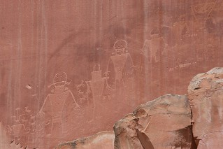
Petroglyphs
I mostly bypassed most of GS-E as it was already 5 PM and I was feeling pretty tired and meh. After driving through nowhere I wondered where some of these little towns got gas, then I’d drive another 15 miles and find another little town with a gas station. I saw Kodachrome State Park and thought it might be curious to visit, but wasn’t very impressed with what I saw. By now I was tired of photographing rocks, but not yet tired enough to camp, and just headed back to the highway on toward Zion and I-15. I passed up Bryce Canyon which I later learned my parents had visited once upon a time.
It was around 9 PM and had just gotten dark when I rolled into Zion. I figured I could find a nice quiet road there to go spend a while. I saw just enough of the canyon around there to perk up and get excited about these new rocks. The have some sweet tunnels running through there somewhere. I took a break at the visitors center and was consumed by the smell of campfires, mmm.
I finally wound up spending the night at a trailhead parking lot just outside of Zion. I want to come back and camp at Zion at least once, it seems like a nice place.
May 1, Zion -> Home
At sunrise at 6, I couldn’t sleep anymore and hit the road back home. It was a pretty uneventful drive back through St George, Arizona, Vegas, Bakersfield, and back home. I hit Pleasanton 5PM rush hour traffic and following the Waze detour, I found out that Pleasanton actually does have a little downtown and main street. I always assumed it was sprawled out SF Bay suburbia.
Mileage
4/27 - 4/28
11:21am  308,150  Fremont, CA
 5:57pm  308,545  somewhere
 6:50pm  308,610  Baker, CA
 7:50pm  308,687  Nevada state line
 8:30pm  308,720  Las Vegas
10:20pm  308,813  Nevada/Arizona state line  8,129 hr
10:30pm  308,847  St George
 1:20am  309,031  Salina
zomg snow
 3:45am  309,187  Moab

4/30
10:45am  309,445  Moab
12:56pm  309,589  Mountain Gas Station
 9:10pm  309,871  Zion

4/31
 6:00am  309,871  Zion
10:00am  310,120  Baker    8,156 hr
 3:55pm  310,498  Nella    8,162 hr
 6:00pm  ??? Home!